Pressure in magma chamber continues to be elevated, new eruption is not ruled out
Update Fri 03 May 2024 03:21
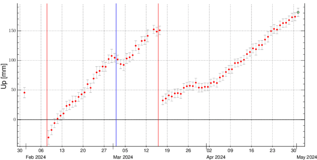
The graph displays the vertical displacement of the GPS station SKSH located in the Svartsengi (image: IMO)
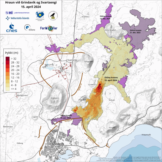
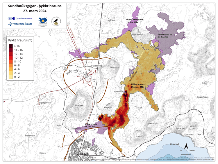
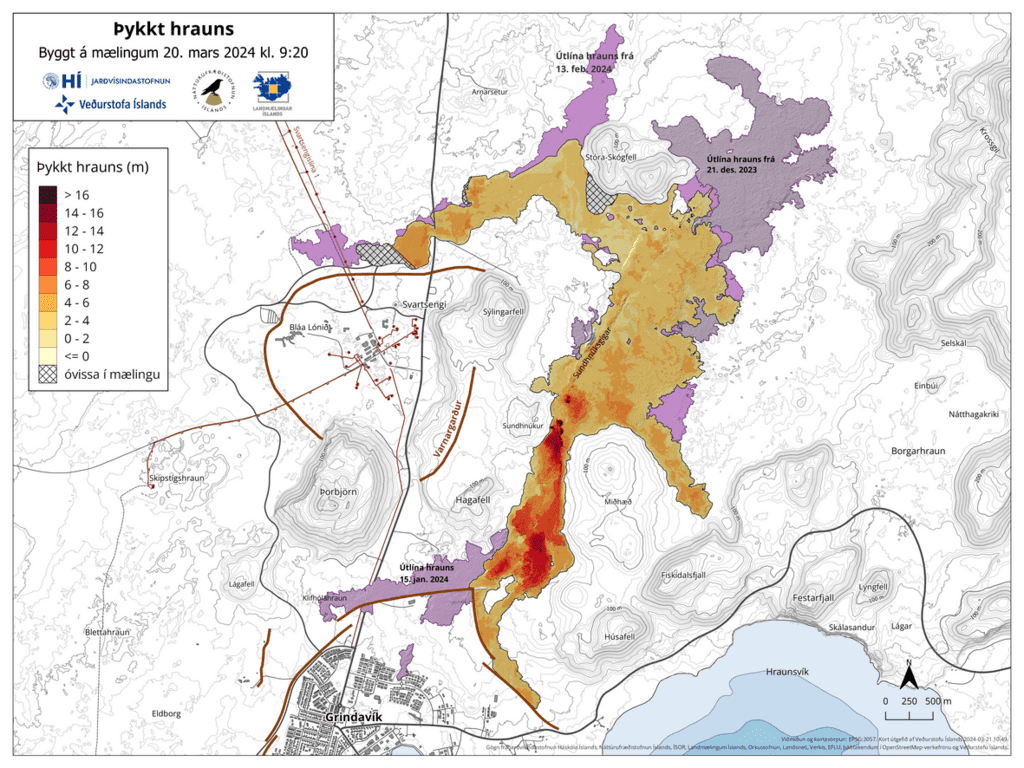
The attached visualization illustrates variations in the lava flow thickness observed on 15, 25 and 30 April (image: IMO)
The ground deformation at the Svartsengi continues.
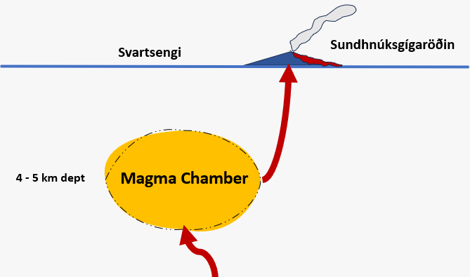
The accumulation rate has remained constant over the past few weeks. Earlier this week, news reports suggested a slowdown in activity, but recent measurements indicate a consistent speed over the preceding weeks. Pressure in the magma chamber continues to build, raising the possibility of a new magma flux from magma chamber beneath the region to the Sundhnúks crater.
The seismic activity has intensified in the Sundhnúks crater series in recent days, characterized by small earthquakes likely indicating tension release around the magma passage due to increased pressure from the Svartsengi magma chamber.
Compared to three weeks ago, lava flow from the crater has significantly decreased.
Source: Icelandic Met Office volcano activity update 3 May 2024Magma volume rises
Update Sat 27 Apr 2024 11:48
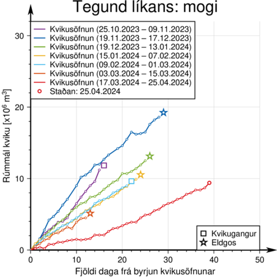
The graph illustrates the estimated accumulation of magma beneath Svartsengi between the periods of volcanic eruptions or magma influxes since November 2023 (image: IMO)
The ongoing increase of magma volume at the Svartsengi region is consistent with models predictions. The total amount of magma, added to the magma chamber since the eruption began on March 16, is now approaching 10 million cubic meters. Historically, magma influxes from the Svartsengi have occurred when the chamber has accumulated between 8 and 13 million cubic meters of magma since the last eruption.
Additionally, there's a possibility of a magma surge leading to new fissures opening outside the usual area between Stóra-Skógfell and Hagafell. However, this scenario is deemed less probable than others and would likely be accompanied by significant seismic activity and deformation, providing more advanced warning compared to previous eruptions.
On Wednesday, April 24, experts from the Norwegian Meteorological Agency carried out measurements of gas emissions from the eruption. It is estimated at 6-9 kg/s of SO 2, but in the last measurement made two weeks ago, on April 12, the gas emission was estimated at 10-18 kg/s. There is no evidence that it is drawing gas emissions from the eruption. While the eruption continues, the flow of SO 2 can vary greatly from day to day (as the eruptions at Fagradalsfjall showed). There is still a risk of gas pollution in the area around the crater as well as in settlements on the Reykjanes Peninsula, and we advise people in the area to monitor the air quality and learn about the reaction to air pollution from the volcanic eruption.
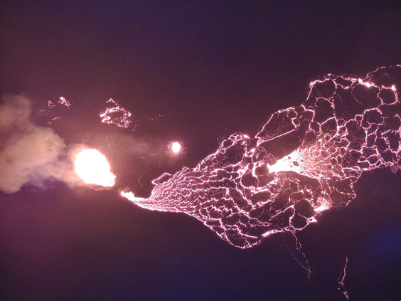
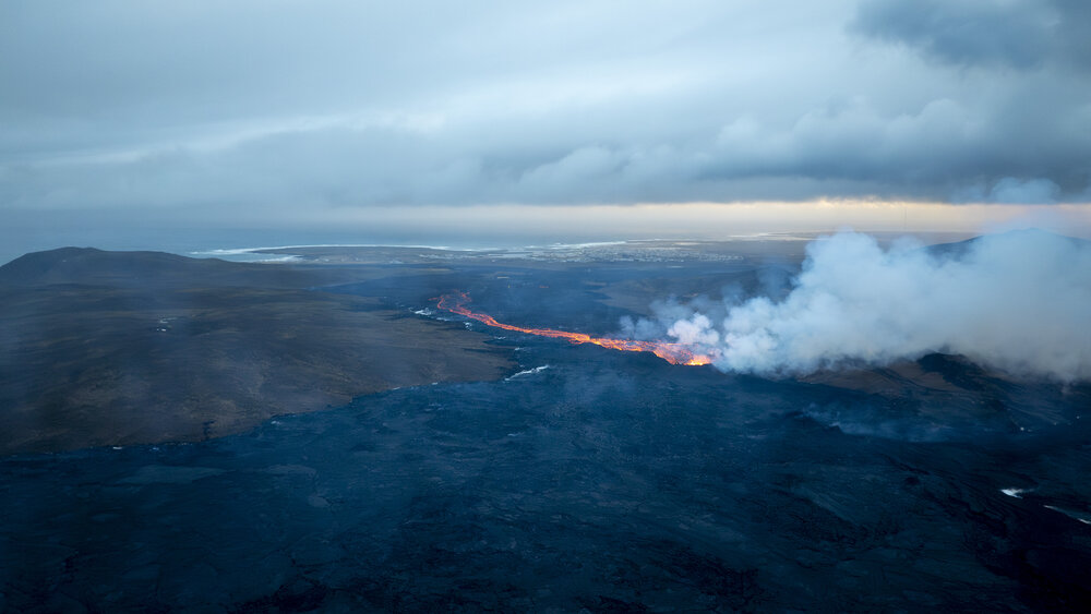
The main crater continues to generate the constant spattering of incandescent, juvenile, and molten pyroclasts, feeding the open lava flow towards the south. The lava travels through the main lava tube system and becomes obscured from view as it progresses further south.
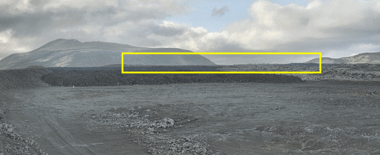
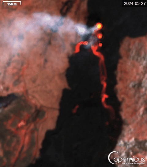
As the attached visualisation indicates, the lava has thickened along protective barriers to the east of Grindavík over the past few days.
Lava has thickened along protective barriers
Update Wed 24 Apr 2024 03:00
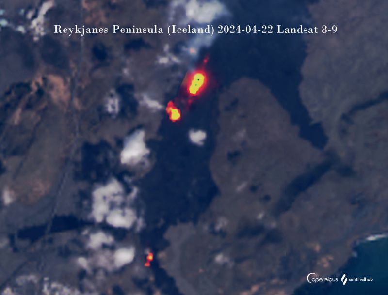
The thermal anomaly in the vicinity of the spatter cone and in the southern part of the lava flow field as seen from space on 22 April (image: Landsat 8-9)
Thickening of the lava flow along the defense wall east of the town (image: IMO)
The eruption continues without any significant change in the activity since the last update.
The main crater continues to generate the constant spattering of incandescent, juvenile, and molten pyroclasts, feeding the open lava flow towards the south. The lava travels through the main lava tube system and becomes obscured from view as it progresses further south.
As the attached visualisation indicates, the lava has thickened along protective barriers to the east of Grindavík over the past few days. The images illustrate the variation in lava width between April 18th and April 23rd. The top photos were captured by the National Defense's webcam situated on a dike east of Grindavík, showing the lava flow advancing towards Suðurstrandarvégur at the eruption's onset. The lower images are from Almannavarnir's webcam atop Hagafell, facing south.
Measurements of the lava flow during the eruption indicate a rate ranging from 3 to 4 cubic meters per second since early April. The most recent measurements were taken from April 15th, and upcoming results expected next week will reveal whether there have been any notable changes in the lava flow since that date.
The ground deformation in the Svartsengi region continues at stable rates, suggesting the ongoing magma accumulation. Model calculations utilizing GPS and satellite data estimate that approximately 7 to 8 million cubic meters have been injected to the magma chamber beneath Svartsengi since the eruption commenced on 16 March.
Source: Icelandic Met Office volcano activity update 24 April 2024Likelihood of new eruption is increasing and could initiate in close proximity to ongoing one
Update Sun 21 Apr 2024 03:15
In early April, a new ground uplift started and might follow another magma accumulation within the magma chamber (image: IMO)
In the Sundhnúkur area, there has been a notable shift in volcanic activity with an increasing chance of magma propagation coinciding with the ongoing eruption. This new development marks a departure from the previous cyclical pattern observed since December.
If magma continues to accumulate at its current rate, the likelihood of another magma propagation event within the next few days or weeks rises, even while the current eruption persists. Notably, the occurrence of magma propagation during an ongoing eruption is unprecedented in this region, adding to the uncertainty surrounding future developments.
Possible scenarios if another eruption would occur:
Magma would flow from the reservoir beneath Svartsengi to the Sundhnúkur crater row, as observed in the last six instances.
Subsequent to this, new eruptive fissures could form between Stóra-Skógfell and Hagafell, or the current eruptive crater could enlarge due to a sudden surge in lava flow, possibly occurring with minimal warning.
If the magma propagation leads to new volcanic fissures elsewhere along the dike formed on November 10, significant seismic activity, deformation, and pressure changes in boreholes would likely provide longer advance notice.
Alternatively, the current eruption's decline may halt and transition into a steady increase until a new balance is achieved between incoming magma and surface outflow from the crater.
However, if the magma propagation results in new eruptive fissures outside the anticipated area, it would likely be accompanied by intense seismic activity and deformation, providing considerably more advance warning than previous eruptions.
Source: Icelandic Met Office volcano activity update 21 April 2024Updated hazard map, eruption continues
Update Fri 19 Apr 2024 04:41
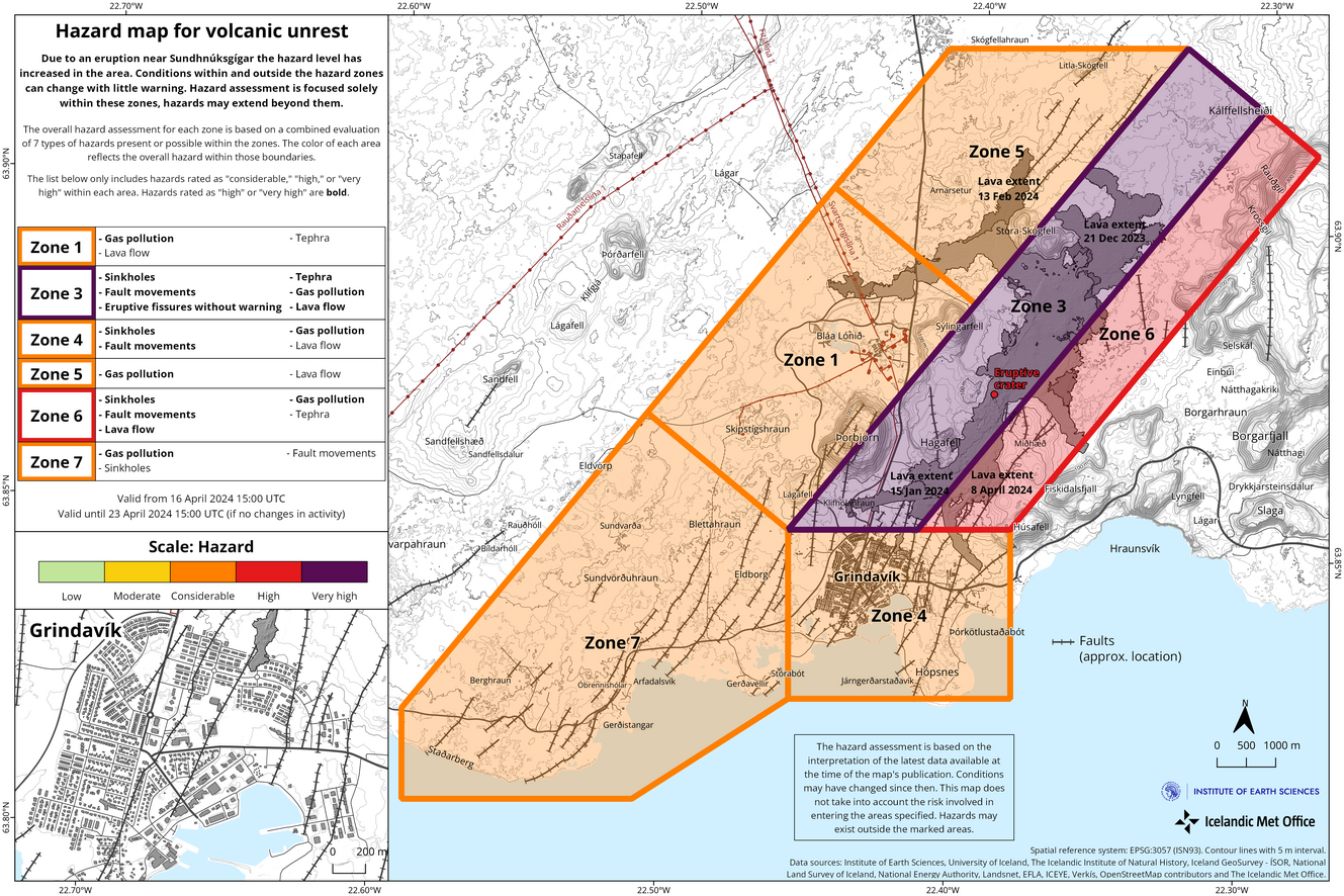
The map is valid from 16 April until 23 April (image: IMO)
The updated hazards assessment will be in effect from 15:00 today until 23 April, pending further developments.
Changes have been made to the assessment, with reduced lava flow hazards in most areas except Zone 3 (Sundhnúkur crater row) and Zone 6. This adjustment reflects the absence of recent lava flows in other regions over the past two weeks. Current eruption activity suggests that lava is unlikely to extend far from the crater into other hazard zones.
Consequently, the overall hazard rating in Zone 4 (Grindavík) has been downgraded from high (red) to considerable (orange). Hazard levels in other areas remain unchanged. The risk from gas emissions remains high across all areas except in the Sundhnúkur crater row area (Zone 3), where it is considered very high. Zones 4 (Grindavík) and 6 maintain a high hazard level due to sinkholes and fault movements.
The activity at the eruption site resumes and has now lasted for a month.
The main crater continues to generate the constant spattering of incandescent, juvenile and molten pyroclasts from where feeds the lava flow in the southern direction.
The lava flows predominantly towards the south but has not traveled a significant distance. Instead, it has accumulated and thickened near the crater rather than extending further in length.
Source: Icelandic Met Office volcano activity update 19 April 2024Swarm of small earthquakes, eruption resumes
Update Tue 16 Apr 2024 02:41
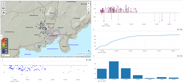
The map depicts the earthquake locations and a depth graph. In the top right, the chart portrays earthquake magnitudes from 13 April afternoon until 14 April night (image: IMO)
On 14 April afternoon, a sequence of minor earthquakes commenced at Lágafell, situated just northwest of Grindavík. The activity mostly subsided by around 4:30 PM yesterday. Approximately 90 tremors occurred, with the peak activity observed between 1:00 and 2:00 PM when 35 earthquakes were detected. All recorded earthquakes registered under a magnitude of 1, most occurring at depths of about 2-4 kilometers. This series of seismic events is likely a result of crustal tension changes linked to the ongoing landslide in Svarteng, as reported in yesterday's news.
Included is a composite map displaying the earthquake locations and a depth graph. Additionally, the top right features a chart showing earthquake magnitudes from yesterday afternoon until last night. Below that, the accumulated number of earthquakes is shown, followed by the hourly count of earthquakes. The graphs illustrate multiple small earthquakes in the area yesterday afternoon, with no seismic activity recorded there after midnight today.
The activity at the eruption site resumes.
The one and only main crater continues to generate the constant spattering of incandescent, juvenile and molten pyroclasts from where feeds the lava flow in the southern direction. The lava has been thickening in the vicinity of the crater rather than advancing further.
Source: Icelandic Met Office volcano activity update 16 April 2024Eruption continues
Update Sat 13 Apr 2024 03:14
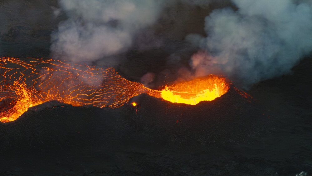
The frequent spattering in the main crater as seen from Sundhnúk on 10 April (image: IMO)
The activity at the eruption site resumes.
The one and only main crater continues to generate the constant spattering of incandescent, juvenile and molten pyroclasts from where feeds the lava flow in the southern direction. The lava has been thickening in the vicinity of the crater rather than advancing further.
The ground deformation at Svartsengi region continues at well-balanced levels, but in early April it increased a bit comparable to the 16-31 March period. It indicates the continuous accumulation of magma beneath the region, causing the elevated pressure. The IMO added: "
During the eruption, however, there is still an open connection between the magma collection area in Svartsengi and the Sundhnúks crater series, and part of the magma flows to the surface there. Variations in the land mass can be seen between days, but overall the speed has been constant since the beginning of April."
Gas pollution from the eruption continues to pose a risk in the populated Reykjanes Peninsula area. Residents are urged to monitor air quality and understand how to respond to volcanic air pollution.
Yesterday's weather forecast predicted northerly winds of 8-13 m/s, decreasing today. This will push gas pollution southward. By late today, winds will shift westward, carrying pollution towards the east.
The risk assessment remains unchanged and will be in effect until 3:00 PM on 16 April.
Source: Icelandic Met Office volcano activity update 13 April 2024Level of activity diminished
Update Wed 10 Apr 2024 02:58
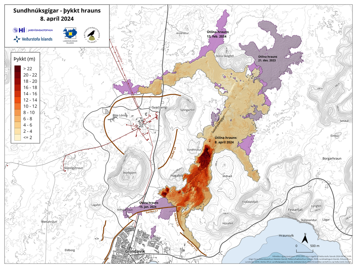
The lava flow map from 8 April portrays its area and thickness since the beginning of the eruption. The purple color represents the lava flow from December 2023 (image: IMO)
Experts from the Institute of Natural Sciences and Land Survey of Iceland conducted a survey flight over the eruptions on 8 April, gathering data to estimate the size of the lava bed and lava flow. The results indicate a steady decrease in eruption intensity.
Lava flow dicscharge rate
The average lava flow discharge rate from craters between April 3 and 8 was estimated at 3.6 ± 0.7 m3/s. This is a decline from the average flow rate of 6.6 ± 0.3 m3/s recorded from March 27 to April 3, as reported by the Efla Engineering Institute based on drone data from April 3.
Lava flow area
The lava bed covers an area of 6.14 km2 with a volume of 31.3 million m3. Recently, the lava has predominantly flowed south from the crater, with a temporary northward surge on April 7 when the crater rim ruptured.
The thickest lava accumulations are observed near the crater and slightly to the south, where activity remains highest within the lava bed. There are no clear indications of lava advancing towards the dikes north of Grindavík, Suðurstrandarveg, or Melhólsnámu, according to the latest observations.
Source: Icelandic Met Office volcano activity update 10 April 2024Abundant lava overflow from main crater followed elevated influx of magma
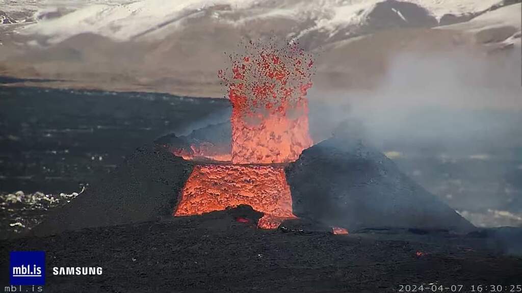
Update Mon 08 Apr 2024 03:52
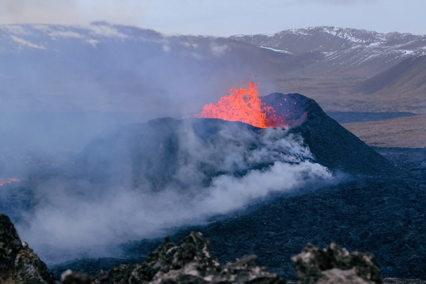
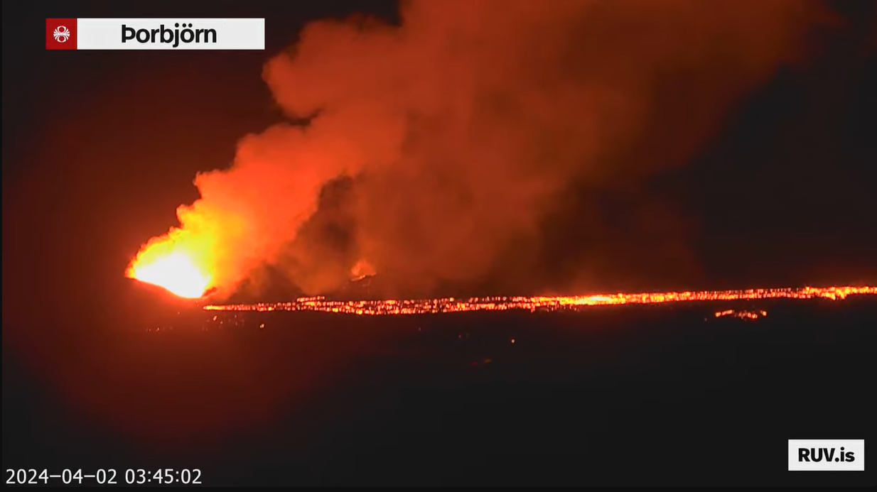
The oozing red-glowing lava overflow from the main crater vent yesterday (image: mbl.is)
Yesterday afternoon, a significant change in the ongoing activity occurred at the main crater. It is strongly believed that the magma reservoir began releasing a new batch of magma, potentially indicating a process of magma recharge. This was followed by an increased discharge of lava around 15:30 local time, featuring a several-hour lasting incandescent, fluid lava overflow from the crater vent, containing a cauldron of boiling lava. The situation stabilized around 21:30 local time last night.
We would like to show you embedded content from X/Twitter. If you like to see this content, please make sure you agree with the
privacy policy of X/Twitter and click the button:
View embedded content from X/TwitterNorthern cinder cone dominates eruption as second crater stopped to be active
Update Sat 06 Apr 2024 21:01
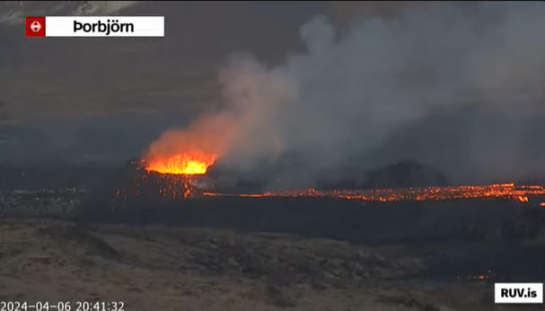
The one and only active spatter cone as of 20:40 local time today (image: RUV)
Gradual cessation of two cinder cones within the 27 March and 6 April time period (image: Sentinel-2)
Another significant change appeared at the eruption site over the past 48 hours.
As we mentioned in the
last update, the northern cinder cone has been showing the most lava-effusion activity of two cones at that time. However, judging at least from the latest Sentinel-2 satellite acquisition from today, the larger, northern crater has become the one and only protagonist of the eruption. In the attached timelapse visualization (27 March-6 April), the southern edifice is no longer active, or it seems to have halted.
Fresh and molten pyroclasts have been continuing to eject from edifices, resulting from continuous spattering that thickens the lava flow field in their vicinity rather than its length, as seen in the attached timelapse.
Northern crater supplies most of lava
Update Fri 05 Apr 2024 06:39
The lava layering from the northern crater (image: IMO)
The eruption continues from two active craters and remains essentially unchanged since the
last update.
The larger, northern cinder cone appears to feed most of the lava flow by layering previous lava flow beds from the eruption's first days. Fresh and molten pyroclasts continue to eject from edifices, resulting from continuous spattering that thickens the lava flow field in their vicinity rather than its length.
GPS statistics showed that the ground has been bulged by 3 cm during 18 March-3 April period.
The IMO added:
"If you look at the GPS measurements over the entire period that the wave interpolation shows, you can see that there is consistency in the results of both measurements. It is an indication that the system is open and magma continues to flow from a great depth under Svartsengi and from there to the surface in the Sundhnúks crater series."
Source: Icelandic Met Office volcano activity update 5 April 2024New lava flow map
Update Thu 04 Apr 2024 03:02
The lava flow map from 27 March portrays its area and thickness since the beginning of the eruption. The purple color represents the lava flow from December 2023 (image: IMO)
A recent lava flow map has been released by experts at Land Surveying Iceland.
According to satellite data processing acquired on 27 March, the current lava volume is approximately 25.7 ± 1.9 million cubic meters, with an estimated lava width of 5.99 square kilometers.
The average discharge rate of magma during 20-27 March was approximately 7.8 ± 0.7 cubic meters per second, which is highly comparable to the lava flow rate observed during the initial phase of the 2021 Geldingadalir eruption.
Source: Icelandic Met Office volcano activity update 4 April 2024Eruption ceased in third cone, while it continues from remaining two
Update Tue 02 Apr 2024 12:46
Two cinder cones continue to be active (image: RUV.is)
The effusive eruption at the site continues at stable levels.
A significant change in the activity has occurred since the
last update. Some time during 28-29 March, the southernmost cinder cone from the crater wall, known as the spatter rampart, appeared to have ceased the lava spattering. Therefore, fresh and molten pyroclasts continue to eject from remaining cinder cones that thicken the lava flow field in their vicinity rather than its length (see
animation on youtube).
Eruption persists from three primary craters
Update Thu 28 Mar 2024 10:16
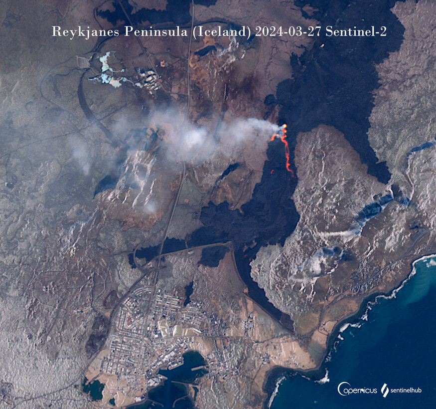
The latest cloud-free satellite image showing three main crater vents and the lava flow (image: Sentinel-2)
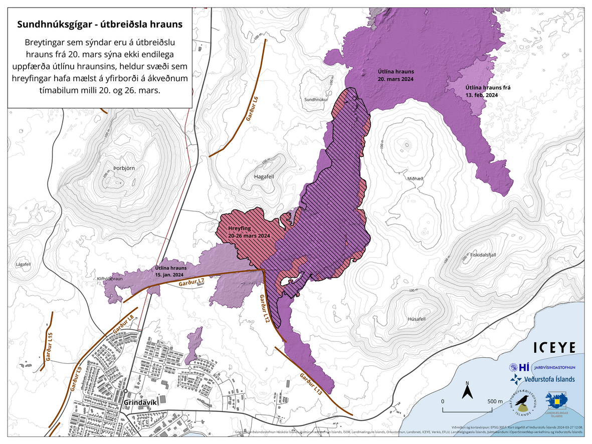
Dashed area represents the lava flow development during 20-26 March (image: IMO)
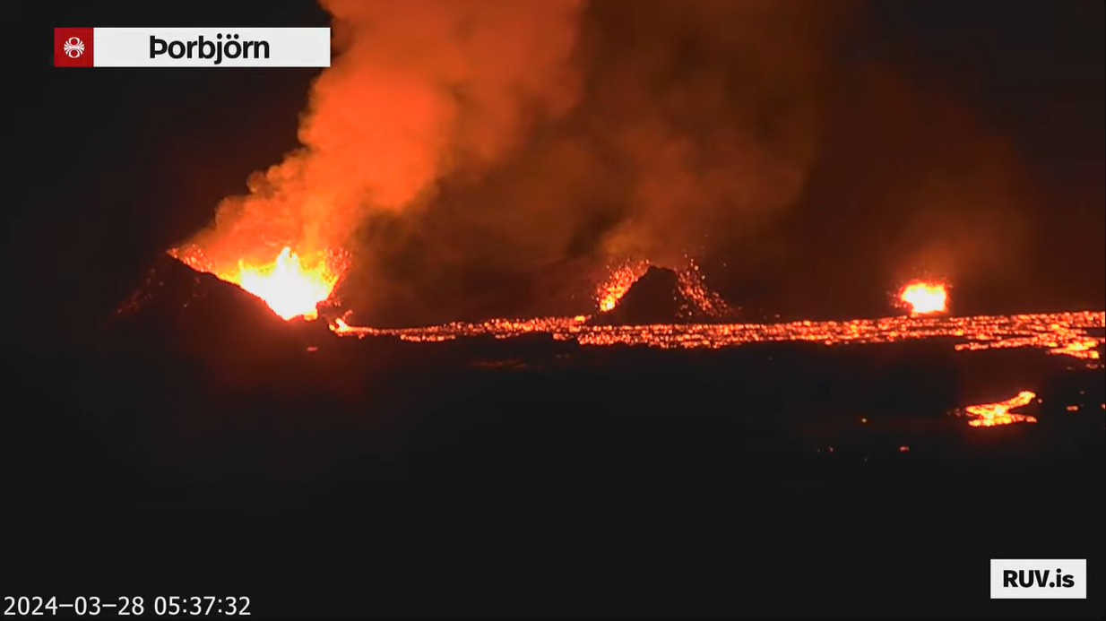
The spattering continues within all three main cinder cones feeding the lava flow (image: RUV webcam)
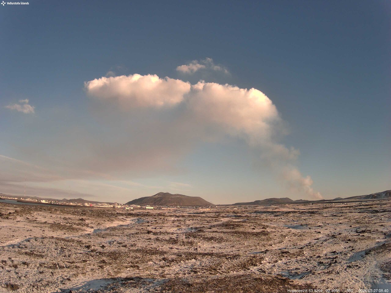
The pyrocumulonimbus over the eruption area (image: IMO)
The eruption continues at stable but at low-level values.
The lava spattering of molten pyroclasts continues from the spatter rampart system. Three dominant cinder cones continue to generate plastic lava fragments that have been building edifices and feed the lava flow towards the south.
GPS measurements indicate the ongoing swelling of the Svartsengi area. The seismic activity continues at low levels, indicating freely movement of magma through dikes without generating any seismic energy.
The degassing becomes more efficient with widening vents as the eruption goes on and affects the area of Grindavík, the Blue Lagoon and Höfn. Significant amounts of SO2 concentrations were measured in the areas last night (9000 micrograms/m3), but they significantly decreased to background values. A large
pyrocumulonimbus cloud has formed over the eruption site. Vapor clouds characteristically develop above open lava flows and erupting vents from the condensation of rising hot air, creating so-called pyrocumulus clouds. When these convectively expanding clouds reach sufficient altitude and size, they transition into pyrocumulonimbus clouds.
The labor inspectorate emphasizes the need for careful attention to outdoor work environments. Companies and organizations situated in the southwest corner of the country must closely monitor air quality due to potential gas pollution risks. The ongoing volcanic eruption is expected to result in continued gas emissions, leading to pollution on the Reykjanes Peninsula. Residents in the area are advised to monitor air quality and educate themselves about responses to volcanic air pollution.
Source: Icelandic Met Office volcano activity update 28 March 2024Eruption has subsided
Update Tue 26 Mar 2024 05:22
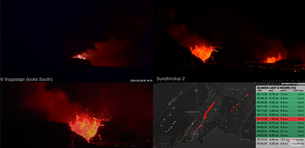
The activity in craters continues at diminished levels (image: Live from Iceland webcam)
The eruption has subsided over the past 24 hours.
The magma supply towards cinder cone vents decreased and it seems that the activity in smallest cones will cease soon.
Lava flows continue to travel southward and then turn to the west. Over the weekend, the lava already filled up the Melhólsnámina, but the closer to the crater, the thicker it is.
GPS measurements indicate the ongoing swelling of the Svartsengi area but at reduced levels.
Source: Icelandic Met Office volcano activity update 26 March 2024Lava flows persist near Grindavík as gas pollution threatens surrounding areas
Update Sat 23 Mar 2024 18:36
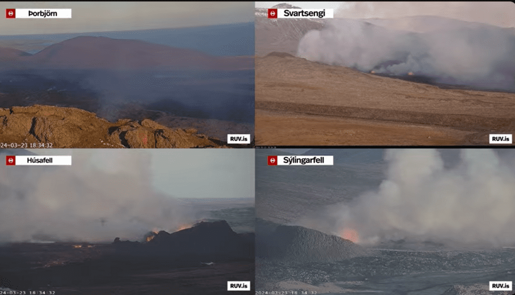
The eruption continues at well-balanced levels (image: RUV.is webcam)
The volcanic eruption continues with relatively steady activity.
The lava is flowing along the defensive wall to the north and east of Grindavík. The lava flowing along the dykes north of Grindavík continues to fill up Melhólsnáma, as depicted in the accompanying animation, which illustrates the lava flow from 15:00 yesterday until 09:00 this morning, March 23.
Today's forecast indicates northeast winds at speeds of 8-15 m/s at the eruption stations. Consequently, gas pollution is expected to drift southwestward and may affect Grindavík. Tonight, the winds are forecasted to shift to the east and southeast at speeds of 5-13 m/s, causing the gas to travel westward and northwestward towards Svartsengi. This may also lead to gas being felt in Reykjanesbær and nearby areas. The situation is expected to calm down by the evening, reducing the likelihood of gas pollution spreading far from the eruption centers. However, there remains a possibility of gas pollution in their vicinity.
Source: Icelandic Met Office volcano activity update 23 March 2024Blue Lagoon will be closed until Monday
Update Sat 23 Mar 2024 05:09
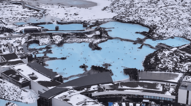
The Blue Lagoon (image:
RUV.is)
The Blue Lagoon announced today that its offices will remain closed until Monday, March 25. The closure is attributed to the volcanic eruption that commenced on March 16, prompting an evacuation and temporary shutdown.
Despite the closure, it's emphasized that the hot springs of the Blue Lagoon are situated at a safe distance from the volcanic activity.
News reports from yesterday revealed that a Blue Lagoon employee had to be hospitalized due to symptoms of poisoning resulting from pollution stemming from the volcanic eruption on the Reykjanes Peninsula. Significant levels of sulfur oxide were recorded in the area yesterday. Today, the Norwegian Meteorological Agency issued warnings of heightened gas pollution in all regions proximate to the eruption in its latest risk assessment.
Source:
RUV.isElevated risk resulting from gas emissions, updated hazard map
Update Sat 23 Mar 2024 04:35
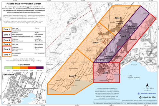
The map is valid from 22 March until 25 March (image: IMO)
The hazard assessment, effective from 15:00 from March 22, until 15:00 on March 25, has been updated. The probability of gas emissions poses a heightened risk across all regions compared to previous days due to adverse weather forecasts for the upcoming days and increased measured levels of sulfur dioxide (SO2) emissions from both the eruption sites and the lava field.
Friday's weather forecast predicts north to northwesterly winds at speeds ranging from 8 to 15 m/s, which will later shift to a more northeasterly direction in the evening with slightly lower speeds. Tomorrow morning, gentler northeasterly winds are expected, and gas emissions are anticipated to primarily disperse south of the eruption sites towards Grindavík.
Updated hazard map
In areas 1 and 5 (northwest of the eruption sites), the risk of lava flows has diminished compared to the preceding three days. This reduction in risk is attributed to the stabilization of the lava flow north of the eruption sites, resulting in a preference for lava to flow southward. Nonetheless, caution is advised as the recently formed lava field remains hazardous.
Source: Icelandic Met Office volcano activity update 21 March 2024Protective barrier levels ordered raised as lava threatens to overflow and enter town
Update Fri 22 Mar 2024 08:11
Scientists and authorities expressed first concerns about lava entering the town of Grindavík.
Artificial protective walls continue to successfully redirect the lava away from the town. However, the molten rock might overflow barriers and enter the town soon. To prevent the lava from arriving, a decision was made to raise barrier levels. Construction was scheduled for upcoming hours.
Source:
RUV.isNew analysis reveals extent and volume of lava flow
Update Thu 21 Mar 2024 19:50
Aerial insight into cinder cones within the eruptive fissure (image:IMO)
The attached map depicts the extent and thickness (image: IMO)
The lava flows from the crater wall area towards the south (image: RÚV English/X)
One of several spatter cones generating molten rock (image: RÚV English/X)
No significant change in the activity has occurred during the past 24 hours and hence the eruption persists at well-balanced levels.
The constant spattering from the chain of seven-to-eight cinder cones, the so-called spatter rampart, continues to feed and keep the southern lava flow active.
Yesterday morning, scientists from the Institute of Natural History and Land Survey of Iceland made a reconnaissance flight over the eruption site to analyze the lava flow.
The area covered by lava flows is estimated to be about
5.58 km2 with a volume of about nearly 21 million m3. The attached map depicts the extent and thickness (mean 16 m; the closer to the craters, the thicker the lava layers) of the lava as of yesterday.
The estimated
discharge rate of magma during 17-20 March was approx.
14.5 m3/s. The supply rate is highly comparable to the 2021-2023 Fagradalsfjall eruptions.
Source: Icelandic Met Office volcano activity update 21 March 2024Stable eruption continues
Update Wed 20 Mar 2024 17:51
The spatter rampart is being constructed due to the ongoing fountaining activity (image: RUV webcam))
The activity has been stable over the past 24 hours.
The frequent spattering in the southern part of the fissure continues to build the crater wall (know as spatter rampart as well), consisting of seven-to-eight cinder cones. Ejected hot, fresh and molten pyroclasts fall to the ground, coalescing thereby feeding the southern lava flow. Its front is approximately 300 meters away from reaching the Suðurstrandarveð road. There hasn't been significant movement since yesterday.
According to the InSAR (Interferometric Synthetic Aperture Radar) satellite image, the ground has been uplifted, even though the latest measurements indicate a decreasing trend. This is likely caused by a direct influx of magma towards the surface instead of being accumulated within the reservoir. If so, once the eruption reaches a delicate equilibrium (between heat and magma supply and loss), it is expected to be continue for a long time.
The seismic activity continues at low levels.
Source: Icelandic Met Office volcano activity update 20 March 2024Petrographic and geochemical analyses suggest similarity to previous eruptions
Update Wed 20 Mar 2024 04:00
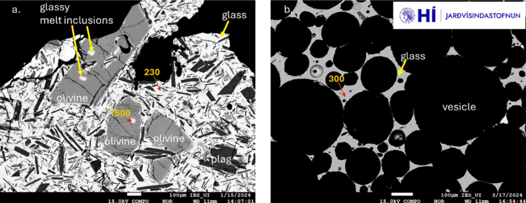
Reflection electron images of (a) lava rapidly cooled (sampled in January 2024) and (b) highly vesicular pyroxene (from March 17, 2024) (image: The University of the Earth Science Institute of Iceland)
The University of the Earth Science Institute of Iceland published results of petrographic and geochemical analysis from the ongoing eruption on the Reykjanes Peninsula.
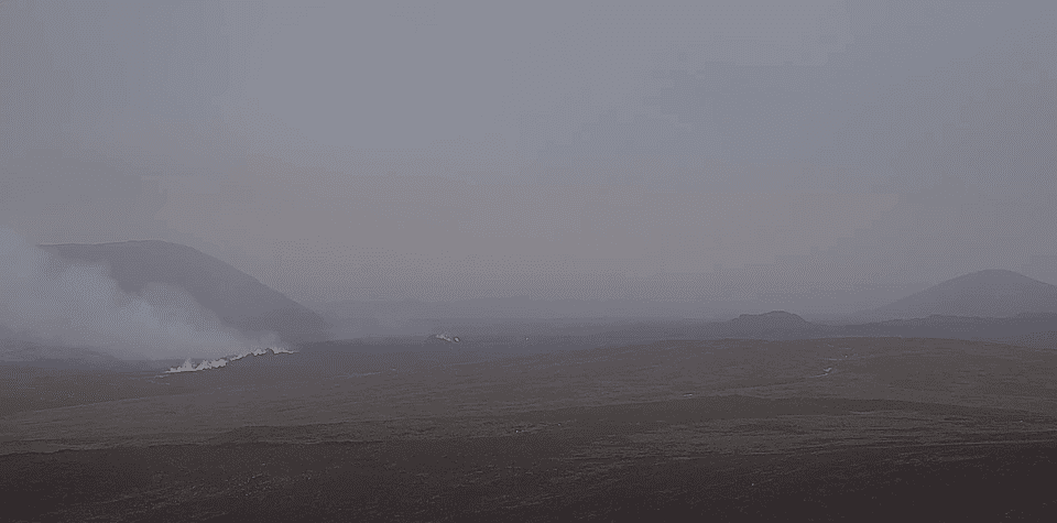
Molten rock samples were taken on March 17 from south of Sýlingarfell and at the southernmost lava rim near Húsafell.
The new lava is similar to previous eruption lavas from Sundhnúksgígir and even to the lava from Sundhnúks craters.
Therefore, the concentration of MgO ranges from 6.0% by mass in the glass of the lava sample's base to 6.8% in the igneous rock. The average analysis of lava samples and igneous rock yields a K2O/TiO2 ratio of approximately 0.21, suggesting a correlation with prior eruptions at the Sundhnúks crater.
Early on March 17, measurements of volcanic gas composition were conducted using infrared Fourier spectroscopy (OP-FTIR). This collaborative project involves scientists from the University of Iceland and the Icelandic Meteorological Office. The gas composition measured is comparable to that observed on January 14th-15th and February 8th. For instance, the mass ratio of CO2/SO2 is approximately 0.8.
Source: The University of the Earth Science Institute of Iceland volcano activity update 20 March 2024Activity continues at stable levels, characterized by formation of line of spatter cones
Update Tue 19 Mar 2024 14:05

Spatter ramparts has been constructing above fissure vents (image: RUV webcam)
The activity at the eruption site continues at stable levels.
In the southern part of the fissure the constant bursting lava spattering has been forming the group of several spatter cones along fissure vents, so-called spatter ramparts.
Most of the lava is going directly into the southern lava flow, with its front approximately 300 meters away from reaching the Suðurstrandarveð road. There hasn't been significant movement since yesterday.
GPS and satellite images suggest that the Svartsengi area continues to inflate, driven by the magma-fed sub-vertical fissure-shaped intrusion, known as dike.
It's important to consider that only a limited number of measurement points have been collected since the eruption began recently, and these measurements are inherently uncertain. Deformation measurements expected in the coming days will enable experts to make more detailed estimations using model calculations regarding the volume of magma flowing beneath Svartsengi.
No significant change in the seismic evolution has been registered.
The eruption has now lasted for over two and half days, making it the longest one of all three previous eruptions since December 2023.
Source: Icelandic Met Office volcano activity update 19 March 2024New hazard map
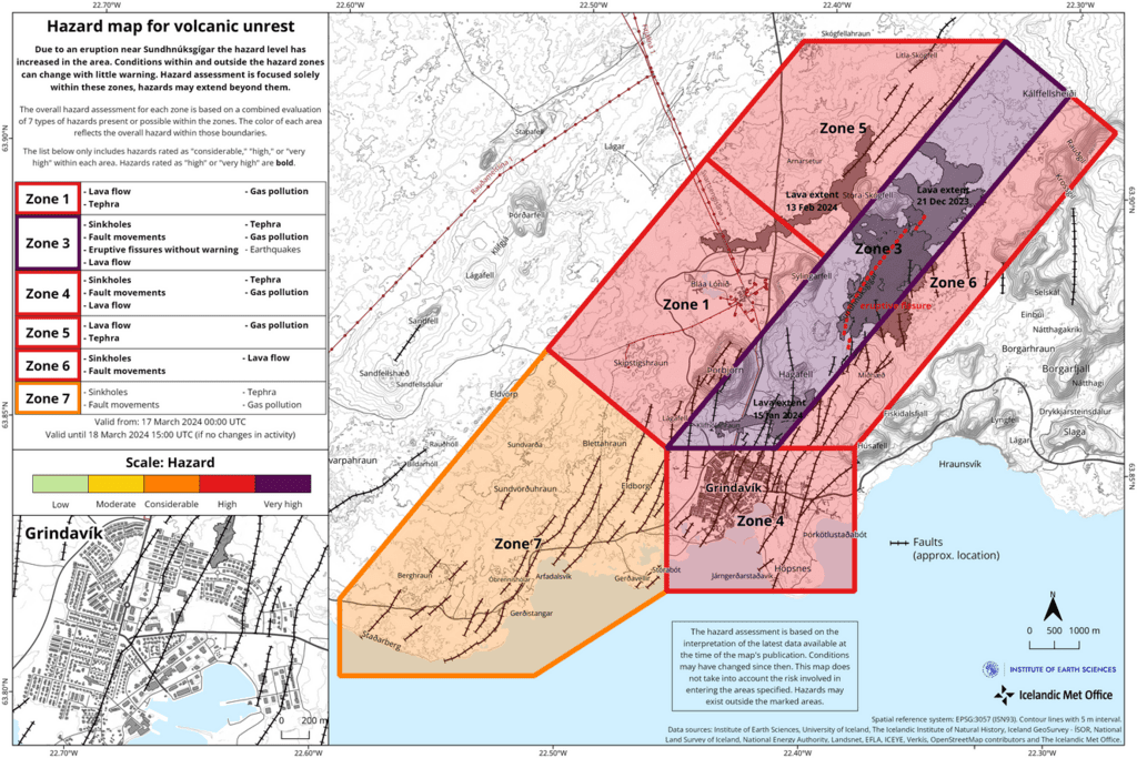
Update Tue 19 Mar 2024 04:14
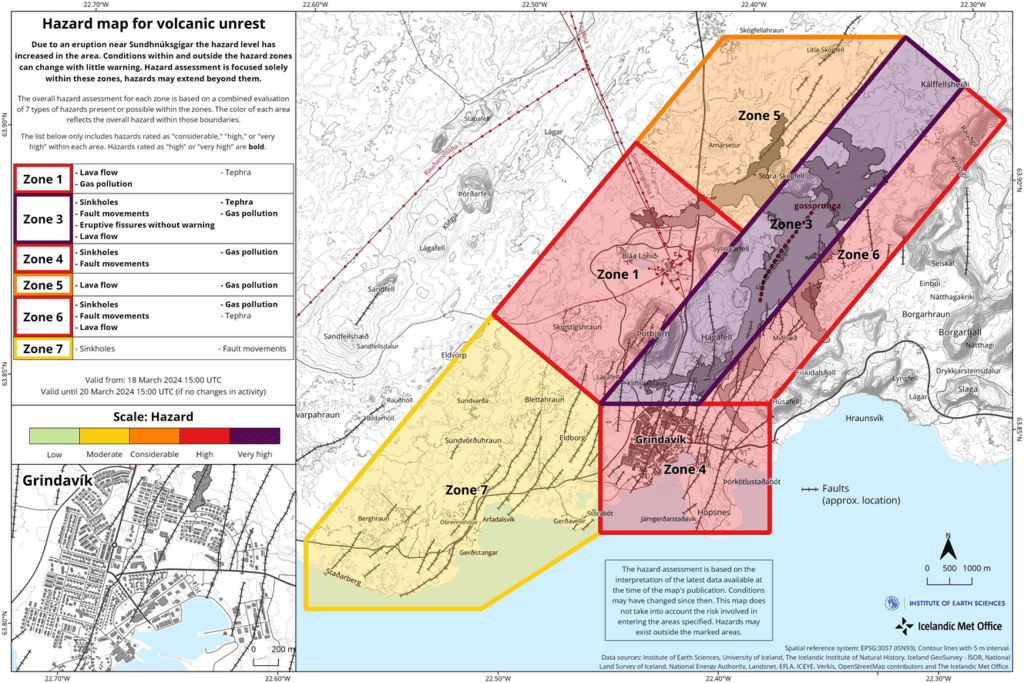
The map is valid from 18 March until 20 March (image: IMO)
The Icelandic Met Office has recently released an updated hazard assessment map for the Grindavík area due to the ongoing eruption. The risk levels have decreased in zones 5 and 7. Zones 1, 3, 4 and 6 remain unchanged.
The most critical danger zones are as follows:
Zone 3, where the eruption goes on, is classified as very high risk, indicated by the color purple.
Zones 1, 4 and 6 are designated as high risk due to gas emissions and lava flows, represented by the color red.
Zone 5 is considered to have a considerable risk, denoted by the color orange, while Zone 7 is assessed as having a moderate risk, represented by the color yellow.
The map is valid from 18 March until 20 March.
Fountaining persists at two locations, with eruption concentrated mostly in southern section of fissure
Update Mon 18 Mar 2024 13:52
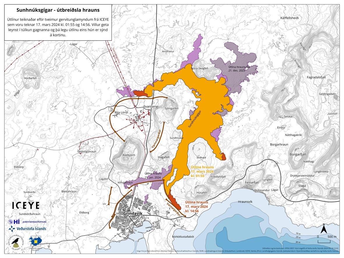
The lava flow area and its extension within a 12-hour time span. The orange color indicates the initial spreading of the lava at 01:55 local time last night, and the red color depicts the lava development from 15:00 local time yesterday. Purple colours show the lava from previous eruptions (image: IMO)
The southern part of the fissure dominates the eruption (image: IMO)
Gas and steam emissions affect the north and northwestern part of the peninsula (image: IMO)
The activity has been stable since late yesterday.
The fountaining is now limited to two clusters of vents, of which the northernmost part appears to have decreased. Thus, the eruption is dominated in the southern part of the fissure, from where the lava keeps the southern arm active. The lava slowly continues to approach the Suðurstrandarveð road; it was about 330 meters to reach the road in the morning.
According to the latest official data taken from satellite image, the area covered by lava flows is estimated to be about 5.85 km2 measured yesterday, although there might be some distortions compared to aerial images. If weather conditions allow, a reconnaissance flight will be made over the eruption site.
Speaking about the weather forecast, a wind direction at the measurement stations is expected to be blowing from east-southeast, reaching a velocity of 8-13 m/s. Thus, a gas pollution supposed to be affect west and northwest parts of the Reykjanes peninsula, including Reykjavík, the capital city.
Source: Icelandic Met Office volcano activity update 18 March 2024Southern lava tongue approaches Suðurstrandarveð road
Update Mon 18 Mar 2024 04:08
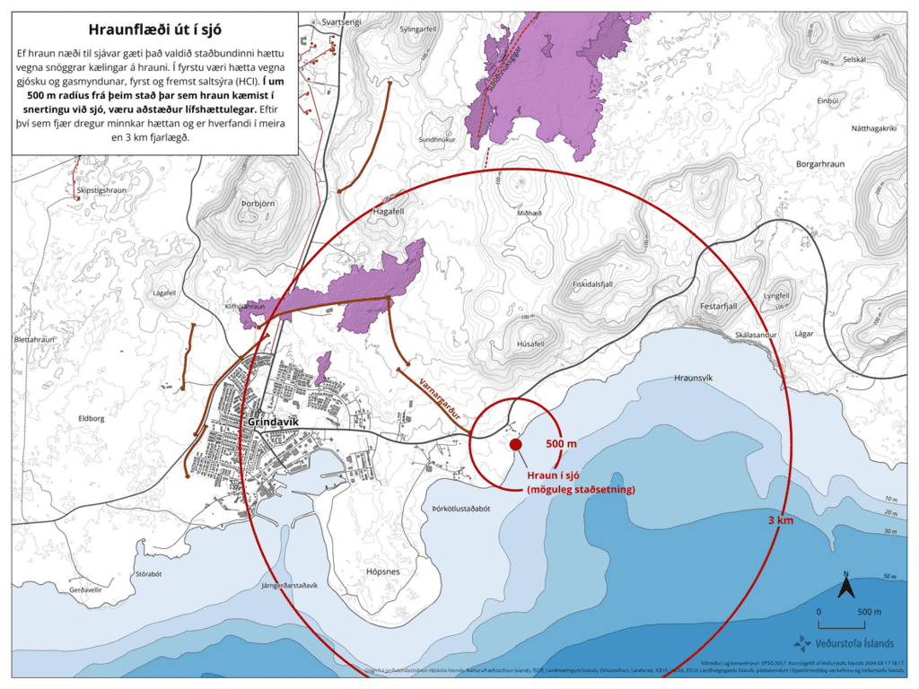
The map portraying the impact area if lava were to reach the sea (image: IMO)
The Icelandic Met Office, Norwegian Meteorological Institute, and Civil Defense have jointly released a map depicting potential scenarios if lava were to reach and enter the sea.
At 18:30 local time yesterday, the southern lava flow front has been less than 250 meters to cut Suðurstrandarveð main road in the south. The current magma supply rate has been approx. 12 m/h (yesterday afternoon). If the lava velocity remains unchanged, it will likely reach the Suðurstrandarveð main road in about less 20 hours (at the time of the IMO update 18:30 local time). In order to reach the sea entry, there is another 350 meters to the sea from the road.
If the lava makes it to the ocean, scientists expect life-threatening conditions within a 500-meter radius. The wider the radius, the lower the risk.
Once lava reach sea, interaction with water is so explosively that forms abundant acidic steam-gas emissions, so-called laze (lava haze). Because laze can be blown downwind, its corrosive effects can extend far beyond the actual ocean entry area.
Source: Icelandic Met Office volcano activity update 18 March 2024Eruption waned considerably, lava arms are advancing along both barrier systems and are likely to bypass Grindavik
Update Sun 17 Mar 2024 17:18
The spattering activity continues from three fissure vents (image: RUV.is)
Model caculations of further advance of lava flows (image: Benjamin Hennig/X)
The activity at the eruption site continues at reduced levels over the past few hours.
The constant spattering generates molten lava fragments and emissions of incandescent lava from three fissure vents only.
Simultaneously, the seismic activity decreased significantly overnight. This follows a very similar pattern in the seismic evolution in compare to previous three eruptions on the Reykjanes peninsula.
According to the latest investigation of the lava flow map, model calculations suggest that the southerly traveling lava flow field will advance along barriers northeast of Grindavik towards the sea. The western lava flow is estimated to pass north of the Svartsengi geothermal plant, which is also protected by artificial walls.
Source: Icelandic Met Office volcano activity update 17 March 2024
We would like to show you embedded content from X/Twitter. If you like to see this content, please make sure you agree with the
privacy policy of X/Twitter and click the button:
View embedded content from X/TwitterTwo lava branches extend in W and SE direction, western lava arm flows across main road, Blue Lagoon has been evacuated
Update Sun 17 Mar 2024 08:17
The lava travels through the main road (image: IMO)
The current eruption site as seen from helicopter (image: Alex Spahn)
The effusive eruption resumes.
Fissure vents continue to feed two lava arms flowing in the western and southeastern direction, respectively.
The westerly spilling lava travels across the Grindavíkurveg road by layering the previous lava flow from February. The southeastern lava branch continues to invade along the protective barricade with an estimated discharge rate of about 300 m/h.
The fountaining continues along the entire chain of eruptive vents, generating juvenile, molten lava clots and gradually has been constructing new spatter cones above vents.
Volcanic gas emissions continue to spread in the east-northeast direction.
A complete evacuation of the Blue Lagoon has been ordered.
Source: Icelandic Met Office volcano activity update 17 March 2024
An aerial insight into the lava flow field (source: Bjorn Steinbekk/X)
We would like to show you embedded content from X/Twitter. If you like to see this content, please make sure you agree with the
privacy policy of X/Twitter and click the button:
View embedded content from X/TwitterNew hazard map
Update Sun 17 Mar 2024 05:20
New hazard map for Grindavík area since the new eruption started (image: IMO)
A new hazard assessment map for Grindavík area has been published by the Icelandic Met Office due to the ongoing eruption.
The danger in the highest risk zones has increased significantly as the new eruption commenced.
The highest danger zones:
3 - very high (purple)
1,4,5,6 - high (red)
7 - considerable (orange)
New eruption started last night, 4th in row since October
Update Sun 17 Mar 2024 05:13
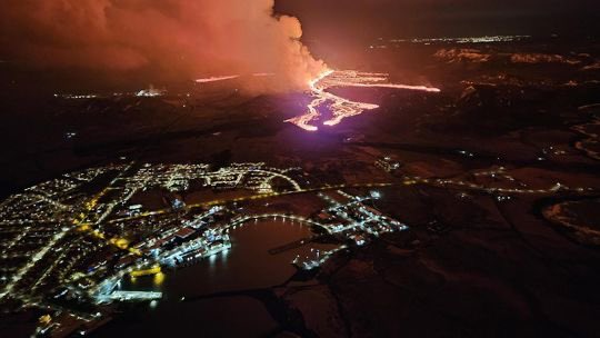
The oozing lava advances toward Grindavík (image: Almannavarnir)
A new effusive eruption commenced on the Reykjanes Peninsula at 20:23 local time.
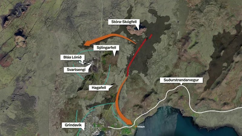
A 2.9 km-long eruptive fissure opened between the Hagafell and Stóra Skógfell mountains. The eruption site location is very similar to that of the recent February eruption.
Impressive lava fountains began to shoot several dozens of meters following the eruption onset. Fountaining continues to pour incandescent and fluid lava from a cluster of vents, feeding a new lava flow in the west direction. A new lava arm branched off the main flow, heading south towards the protective barriers. Unfortunately, the lava is (highly likely) on the way to the Grindavík and might hit the town.
At about 22:10 local time, the lava lobe front was approx. 200 meters from the artificial barrier, located in the eastern part of the town of Grindavík. At 22:20 local time, the lava flow was about 700-800 meters away from the Grindavíkurvegur road.
Given a current magma supply rate, about 1 km per 1-1,5 hour, the lava might reach the shoreline and enter the sea.
The eruption came during a very short phase of generally a low seismic activity and had only 40 minute-long precursor. The Department of Civil Protection and Emergency Management received the first signal at 19:43 local time, the eruption followed 40 minutes later. Sulfur dioxide is contained in solution in magma at greater depths, but as magma is getting closer to the surface and is under less pressure, i.e. undergoes decompression, its solubility decreases with decreasing pressure, thus leaves magma sooner through cracks fumaroles form or by diffuse degassing. Since gas is much more mobile than molten rock (magma) itself, it usually arrives at the surface before eruption starts as we see in the attached eruption onset video.
From initial reconnaissance flight, aerial images and webcameras, the fourth eruption in a row since October 2023 is considered among the largest of previous three events so far.
Source: Icelandic Met Office volcano activity update 17 March 2024
Links to webcams:
Grindavik - Mosaic
Grindavik - Mosaic
Grindavik - Mosaic 2
Þorbjörn
Þorbjörn 2
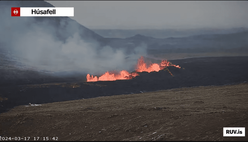
Húsafell
The eruption onset (source: @RUVfrettir/X)
We would like to show you embedded content from X/Twitter. If you like to see this content, please make sure you agree with the
privacy policy of X/Twitter and click the button:
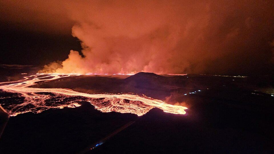
View embedded content from X/TwitterThe lava flow continues to advance towards Grindavík (source: @h0rdur/X, @mblfrettir/X)
We would like to show you embedded content from X/Twitter. If you like to see this content, please make sure you agree with the
privacy policy of X/Twitter and click the button:
View embedded content from X/TwitterReykjanes peninsula (SW Iceland): magma instrusions persist, indicating imminent eruption
Do, 14. Mär 2024, 05:01 05:01 AM | VON: MARTIN
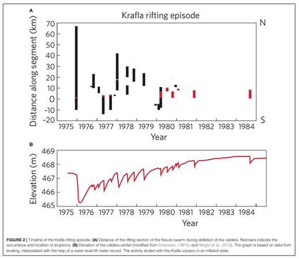
The interaction between magma intrutions and ground uplift in the center of the Krafla caldera. The graph below shows the elevation of measurement point within the Krafla caldera and the graph above shows the distance from the caldera to the dike formations (image: IMO)
Magma intrusions beneath the Svartsengi region continue at a constant rate.
Model calculations estimate about 8-13 million m3 of magma to be accumulated in the magma reservoir so far and already reached the treshhold. A cumulative pressure under the reservoir roof continues to increase and might result in a sudden release of CO2-rich bubbles trapped beneath it, leading to a vigorous lava-fountaining eruption onse. Therefore, the likelihood of a new dike propagation on the surface is highly likely within the next few days.
The seismic activity in the region has slightly decreased over the past few days. The seismic network detected approx. 40 quakes in the vicinity of Sundhnúkur crater row and Grindavík over the past week. The most of earthquakes has not exceeded M 1.0. The strongest event was measured on 8 March with magnitude M 2.8 at about 5 km depth, located southeast of Þorbjörn.
Krafla's Predictable Intrusions vs. Svartsengi's Irregular EruptionsScientists will continue to collect data and analyze whether the event on March 2nd suggests potential alterations to the atypically rhythmic sequence of volcanic unrest characterized by magma accumulation at Svartsengi, along with repeated dyke intrusions and eruptions. Previously, these episodes of unrest have been likened to the events at Krafla, which commenced in 1975. Over a span of 10 years, Krafla experienced 20 instances of magma intrusions, with 9 resulting in volcanic eruptions (refer to the image below). In contrast to Krafla, where magma consistently intruded into the same dike albeit varying in magnitude, the eruptions at Svartsengi's Sundhnúkar crater row have displayed an irregular pattern, deviating from the observed rhythmicity.


