Activity remains weak, volcanic unrest decreases
Update Wed 24 Feb 11:47
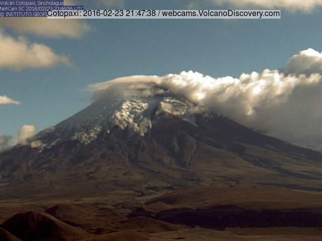
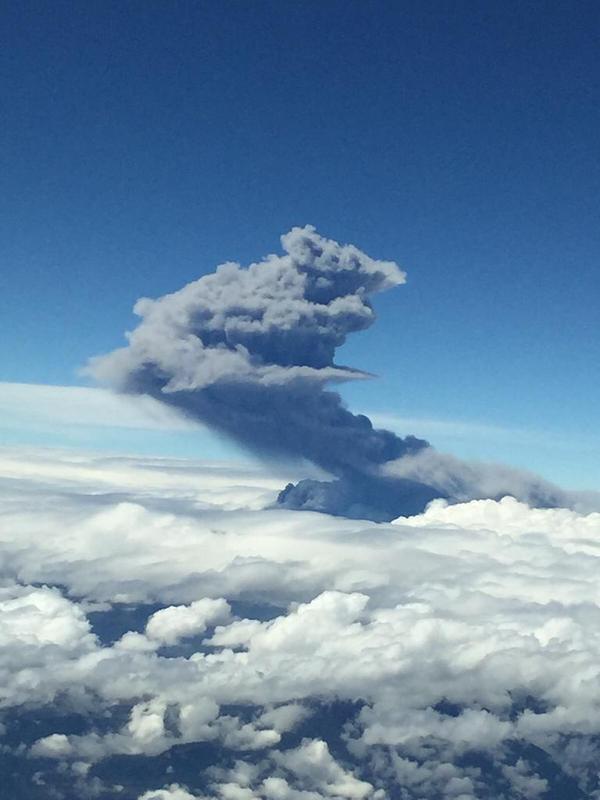
Cotopaxi volcano in calm yesterday
Surface activity of the volcano has been mostly low during the past weeks, characterized by degassing / steaming and occasional very weak ash emissions.
According to IGEPN, the level of most monitored geophysical parameters (SO2, volcanic earthquakes, volcanic tremor, deformation) have returned to their pre-eruption background levels.
base. However, the overall seismic activity of the volcano is still elevated and some few deep-seated explosive events are being recorded (on average 1-3 / day).
This type of activity possibly indicates that a magma source remains active inside the edifice. The most likely scenario of the coming days to weeks is that surface activity remains at a low level and or continues to decrease, with intermittent small ash emissions possible that would not affect but immediate areas surrounding the volcano. However, even though much less likely now, an increase in internal and external activity of the volcano cannot be excluded either.
Although not directly connected to its activity, as a secondary effect, the risk of lahars (mud flows triggered by melt water) remains elevated.
Intermittent weak ash emissions
Update Sat 06 Feb 11:23
On 29 January IG reported that in recent weeks superficial activity at Cotopaxi was characterized by minor steam emissions from the crater and sporadic gas emissions with minor amounts of ash.
Sulfur dioxide emissions were less than 1,000 tons per day (pre-eruptive levels) and seismicity had almost returned to baseline levels. At 1843 on 24 January a plume with low-to-moderate levels of ash rose 700 m above the crater and drifted W. The emission coincided with a hybrid earthquake.
(Smithsonian / USGS Weekly Volcanic Activity Report 27 January-2 February 2016)Intermittent weak ash emissions
Update Sat 21 Nov 06:43
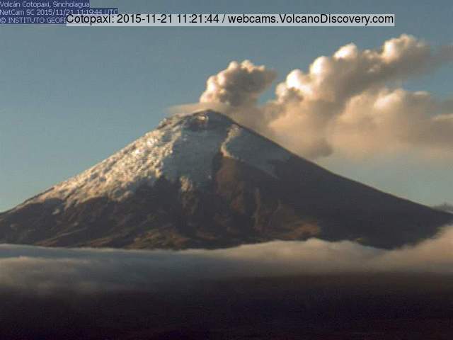
Small ash emission from Cotopaxi this morning
The volcano's activity remains low, with intermittent small ash emissions and continuous steaming. Weak glow can sometimes be observed at night. According to IGEPN, seismic activity remains moderately strong.
Continuing intermittent ash emissions
Update Wed 11 Nov 17:24
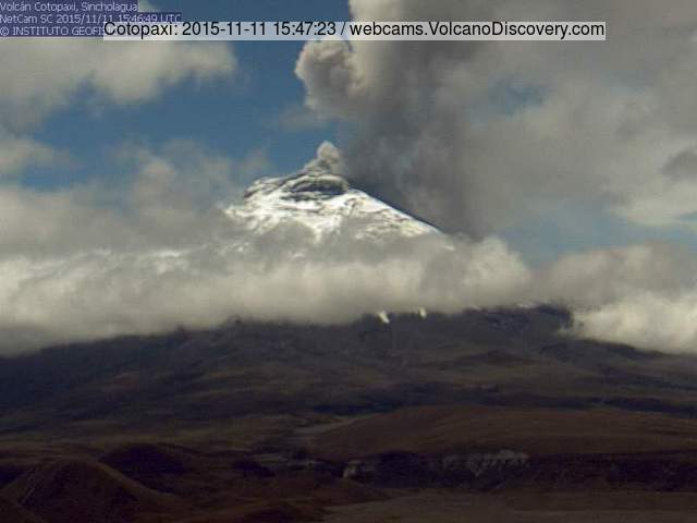
Moderately strong ash emission from Cotopaxi this morning
Intermittent explosions continue at the volcano. IG reported that during 4-10 November gas, steam, and ash plumes rose almost daily from Cotopaxi as high as 1.5 km above the crater.
Minor ashfall was reported S of the volcano on 6 November, and small lahars descended the W flank during 6 and 8-9 November.
Continuing steam emissions, small explosions
Update Thu 29 Oct 15:43
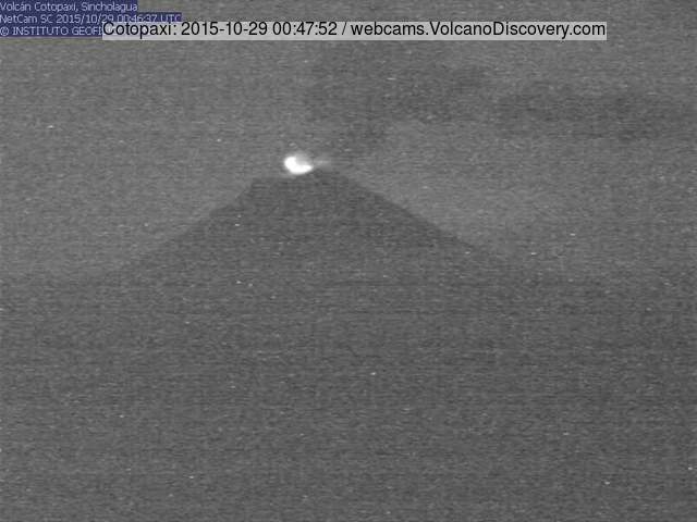
Steam emissions and glow from Cotopaxi this morning
No significant changes in the volcano's activity have occurred. According to monitoring scientists from IGEPN, it seems that magma is slowly rising inside an open-conduit system.
During the last week, visual activity mainly consisted in steam and gas emissions reaching 1-2 km height, as well as small explosions in the crater that could only be detected instrumentally. Ash emissions have been minimal. Overall seismic activity has slightly decreased, with averages of 30-50 volcano-tectonic earthquakes (VT) per day. SO2 emissions remained high, fluctuating at values of 2000-5600 tons / day.
Intense degassing, mild ash emissions
Update Mon 26 Oct 10:37
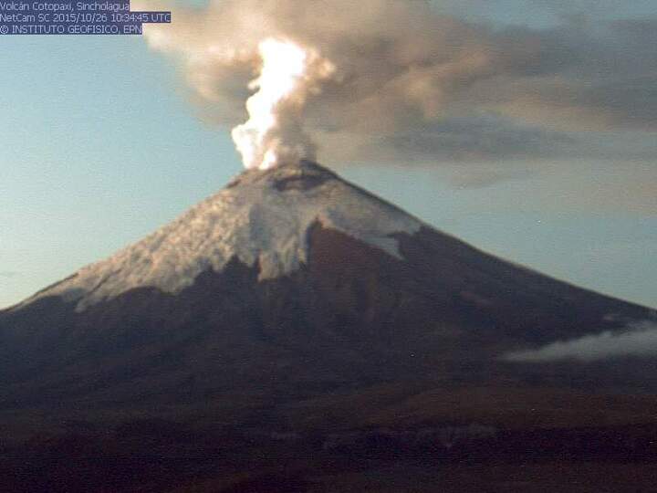
Cotopaxi volcano today
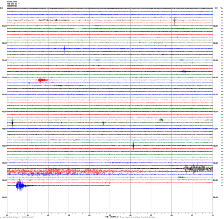
Seismic recording (VC1 station, IGEPN)
No significant changes have occurred during the past days. The activity remains characterized by intense degassing and occasional mild ash emissions mixed into the plume.
Speculation about the eruption's near future development
Update Tue 20 Oct 18:07
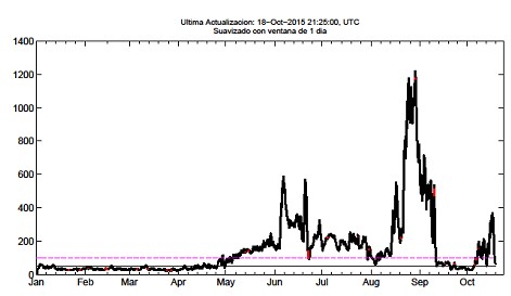
Seismic energy of Cotopaxi during the past weeks
Number of volcano-tectonic quakes during the past weeks
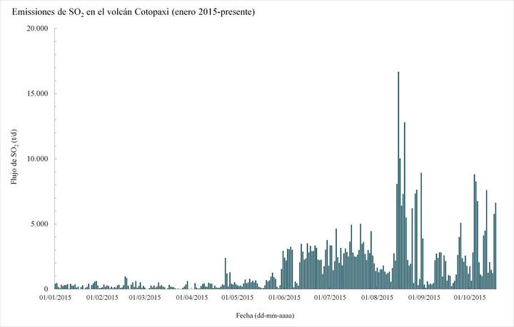
SO2 emissions from Cotopaxi
The volcano's activity has been similar as during the past weeks. It continues toerupt a weak to moderate steam plume with more or less ash content, rising up to 1.5 km above the summit crater. Occasional weak ash falls have occurred in areas to the west and southwest of the volcano.
The following is drawn from the latest, very detailed report of the Istituto Geofisico (link below):
Seismic activity, dominated by shallow (less than 12 km deep) rock-fracturing volcanic earthquakes has decreased in numbers, but increased in total energy since the end of September. SO2 emissions remain elevated, ranging between 1,000 and 7,600 tons / day.
Most likely scenario for the near future:
According to scientists from IGEPN, the most likely scenario is that the volcano will continue to produce small emissions that might become gradually stronger, as a new batch of magma is slowly rising within the volcano, until the supply is depleted after some weeks of activity. Explosions of small size are likely to occur as well, but ejecta from such are expected to be limited to the summit area.
Associated phenomena are likely mud flows (lahars) caused by melting of ice from the volcano's summit region.
Seismicity
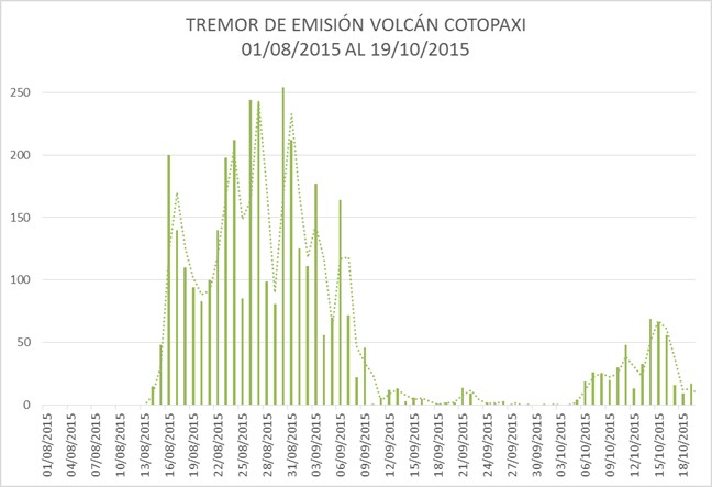
During the last week, the activity of Cotopaxi volcano was characterized by the sporadic presence of seismic signals associated with emissions, called tremors emission, and the generation of volcano-tectonic earthquakes (VT) at an average of ~ 50 events / day. The magnitudes of the VTs were generally less than 1, but some magnitude 2.7 events were recorded n October 14. Emission tremor was characterized by low to moderate amplitudes and duration of between 1 and 12 hours. The energy associated with the seismic activity slightly decreased from the second to third week of October.
Most VT events were located less than 9 km beneath the crater.
Deformation
No clear trends were observed during the past weeks.
Other scenarios
Besides the mentioned scenario believed most likely (nr 1 in the report), assuming a gradual, continuous, relatively mild release of energy, IGEPN mentions other possibilies:
2) moderate vulcanian explosion scenario:
The conduit becomes plugged, leading to an increase in pressure. Eventually, the magma pressure overcomes the resistance of the cap, producing one (or more) moderate to large explosions with significant ballistic ejecta reaching up to 5 km distance, and possibly small to moderate pyroclastic flows (such as Tungurahua did in July 2013).
Ash falls could be moderate to strong in the prevailing wind directions with an accumulation of a few millimeters to a few centimeters of ash.
Additionally, significant lahars could form and threaten areas of the Cotopaxi National Park, but also populated areas near the main drainages around the volcano (rivers Pita, and / or Cutuchi and / or Aláquez and / or Jatunyacu).
3) Large vulcanian explosion scenario:
The ascending magma is much larger in volume and rises faster than anticipated. This could lead to a major explosive eruption that generates large pyroclastic flows on all sides of the volcano, heavy ash fall, and large mud flows, such as the eruption of Cotopaxi in June 1877.
4) Activity fades, magma does not reach crater scenario:
It is also possible that the eruption slowly fades, and that magma doesn't reach the crater. At the moment, this seems to be the least likely of the 4 scenarios.
Source: Actualización de la Actividad Eruptiva--Volcán Cotopaxi N° 20 - 2015 (IGEPN report 19 Oct 2015)
Intermittent explosions and ash emissions
Update Sun 11 Oct 10:26
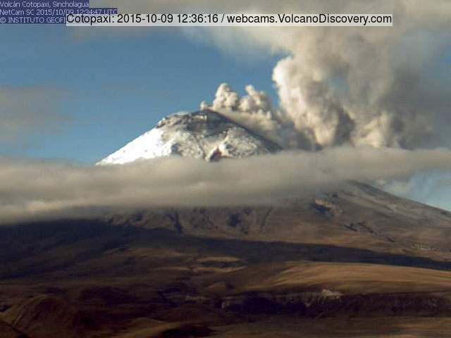
Ash emission from Cotopaxi on 9 Oct 2015
During the past days, intermittent explosive activity has resumed at the volcano's summit crater. Intense activity on 8 and 9 Oct generated ash plumes that rose up to 1-1.5 km height above the crater and drifted to the west.
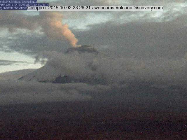
Incandescence at crater suggests magma approaching vent
Update Sat 03 Oct 09:17
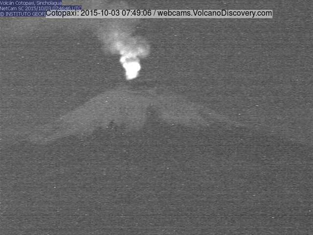
Glow from Cotopaxi's crater this morning
Steam plume from Cotopaxi last evening
Visible activity of the volcano has been relatively low during the past week. Only a strong steam plume mixed with low ash contents has been emitted, but there has been a significant change: incandescence has now become visible from the crater. According to scientists from IGEPN, the glow originates from high-temperature gasses. However, this suggests that magma continues to approach the vent, and that the eruption might now be about to become magmatic.
The latter means that the volcano starts to erupt fresh magma, not, only older fragmented material during phreatic (steam-driven) ash explosions as it has been doing so far. According to IGEPN, this could be premonitory of a new eruptive phase characterized by small to moderate explosions that could expel incandescent blocks outside the crater, accompanied by new ash emissions.
Continuing mild to moderate ash emissions
Update Mon 21 Sep 07:57
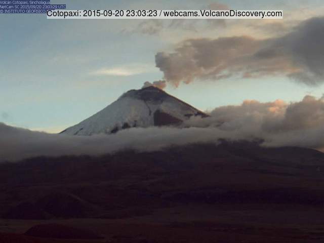
Ash plume from Cotopaxi last evening
The volcano remains active at low to moderate levels (seismicity and emissions). It continues to produce mild ash emissions that usually drift westwards and rise approx. 1 km from the crater.
The government continues to train local people from potentially endangered zones, responsible for small groups, to be prepared and react in case of emergency. Measures include lectures on contingency planning on family level, emergency kits and evacuation route maps.
Crater temperatures increase
Update Wed 09 Sep 17:41
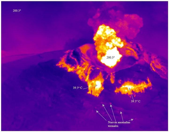
Thermal image of Cotopaxi's crater on 3 Sep (image: P. Ramón IG/EPN)
Image of the crater
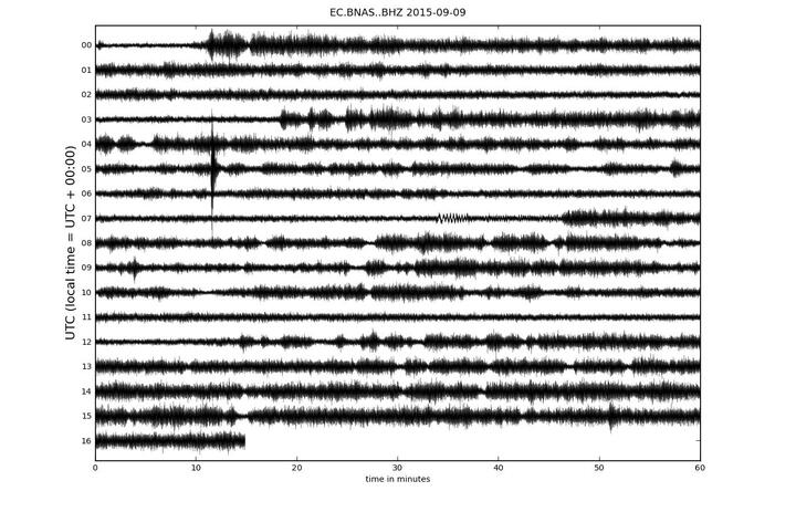
Current seismic trace (BNAS station)
The activity at volcano continues, but has been less intense during the past days. Weak to moderate intermittent explosions produce ash plumes that vary in height from a few hundred to 1000 meters.
The ash was analyzed in a Belgian laboratory and apparently consists only of fragmented older rocks from the upper conduit. This means that the activity so far has been phreatic in origin and not involved fresh magma. It remains uncertain whether or not it will lead to magmatic activity, i.e. whether or not fresh magma arrives at the vent.
Increasing temperature
During an aerial survey on 3 Sep, IGEPN staff observed that the temperature of the ash plume has risen by 33% compared to a previous measurement from 26 August. New warm spots have appeared on the upper flank of the volcano as well. One possible (but not necessary) interpretation could be that the magma batch inside the volcano has been rising. On the other hand, seismic activity, although still high, has decreased and not shown a clear trend towards getting shallower.
The observed increase in temperature could also reflect the effect of thermal erosion by increasing hydrothermal activity (heated circulating fluids in the upper part of the edifice), without actual magma movements.
In the meanwhile, authorities continue preventive measures in case of evacuations becoming necessary: maps with designated evacuation routes have been distributed to over 2000 families, shelter facilities set up and a network of local coordinators established.
Eruption continues with little changes
Update Fri 04 Sep 09:10
Eruption column of Cotopaxi on 2 Sep (image: P. Espin / CotopaxiPungo lodge)IGEPN)
SO2 emissions from Cotopaxi (IGEPN)
Ash plume dispersal forecast (31 Aug - 1 Sep / VAAC Washington)
Ash plume dispersal forecast (1-2 Sep / VAAC Washington)
Activity continues at similar levels as during the past days, with emissions of steam and ash, rising to heights of 1-4 km and drifting into westerly directions where fine ash fall occurs and accumulates to now several millimeters in places.
Compared to the previous week, activity - both at the surface (ash emissions) and internal (seismicity) has been somewhat lower.
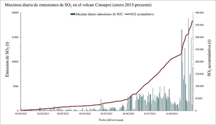
Volcanic SO2 gas emissions remain very high (up to 15,000 tons/day), suggesting that a significant amount of magma is stored inside the volcano and continues to intrude into shallow dikes and reservoirs.
On 2 Sep, an eruption column reached 4 km height and fine ash fall was recorded in Sto. Domingo de los Colorados and Manabi.
At the entrance of Cotopaxi National Park (01 Sept-15), ash accumulation is several millimeters thick (photo Minard Hall / IGEPN)
Estimation of total erupted ash so far: VEI=1
Update Fri 04 Sep 09:17
IGPEN estimates that the total volume of ash erupted so far is about 630,000 m3 weighing about 700,000 tons. This would make the eruption rank so far as VEI 1 only.
(
The Volcanic Explosivity Index relates the amount of material erupted during an eruption on a logarithmic scale (from 0 to 9) similar to the Richter scale for earthquakes. For comparison, the eruption of Krakatau in 1883, one of the largest in the past 150 years, was VEI 6).
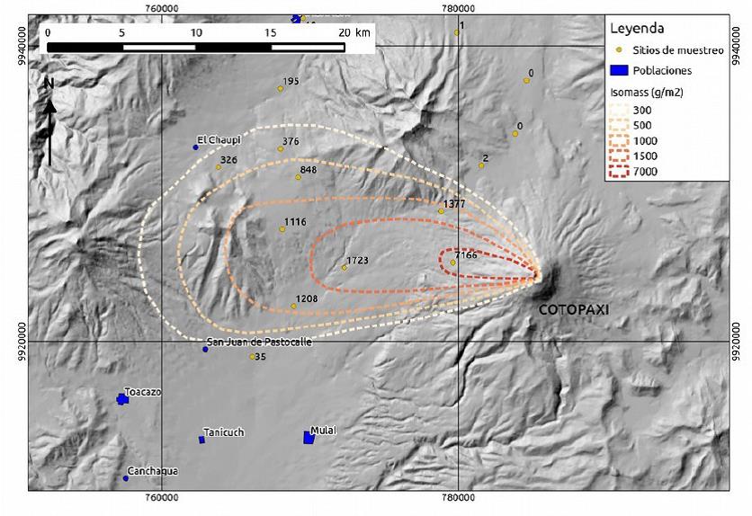
Map of ash fall from Cotopaxi (IGEPN)
Volcanic tremor pulses
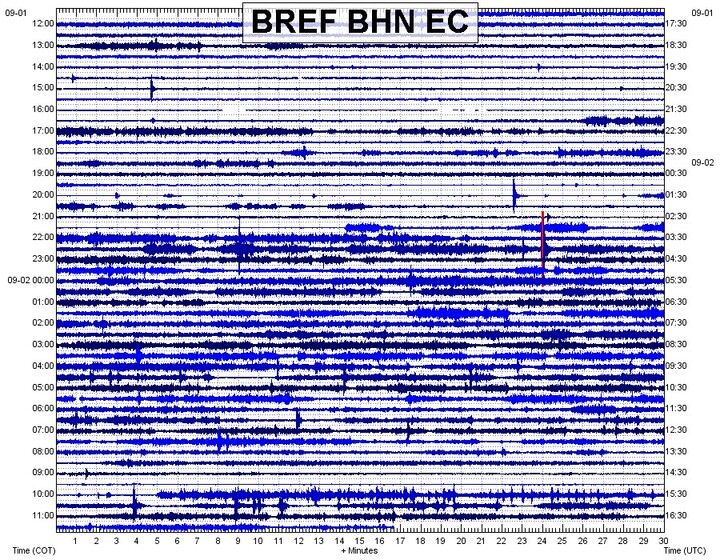
Seismic signal from BNAS station on 2 Sep (IGEPN)
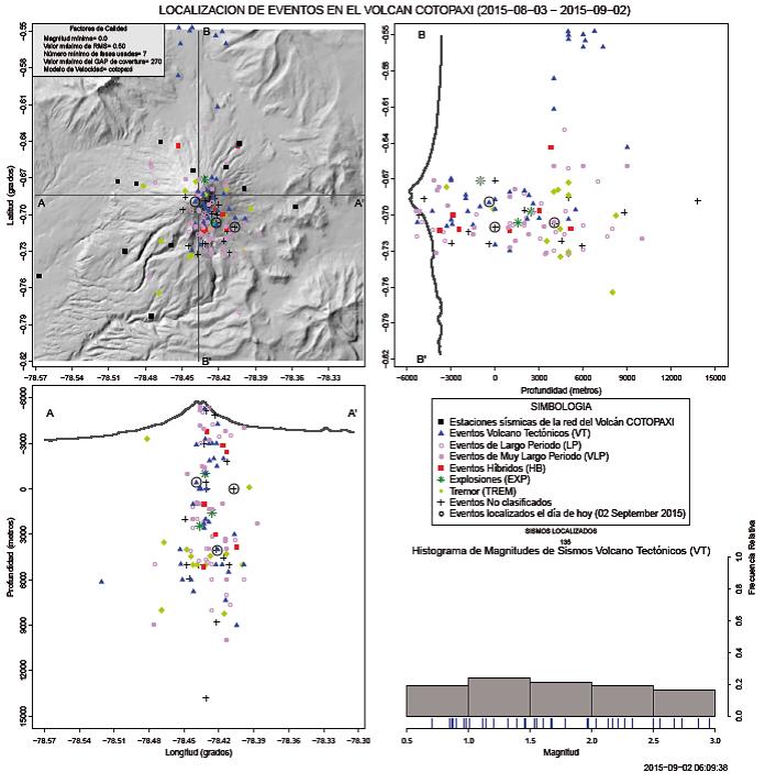
Location of earthquakes (IGEPN)
On 1-2 September, rock-fracturing earthquakes of magnitudes up to 2.7 and tremor episodes occurred. The hypocenters of these earthquakes were located between 3 and 11 km depth beneath the summit.
Activity continues with decreasing trend
Update Mon 31 Aug 16:59
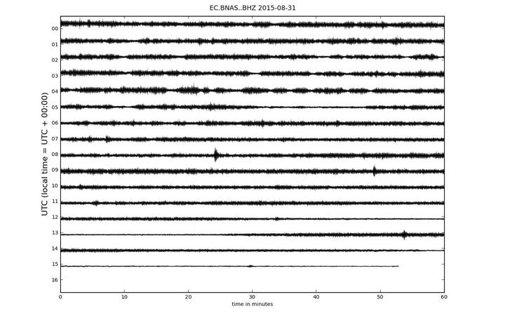
Current seismic trace (BNAS station)
Activity at the volcano remains high while seismic activity has been showing a decreasing trend today and been described as moderate by the Geophysical Institute.
During last night and this morning, ash and steam emissions continued, producing a plume that drifted WNW.
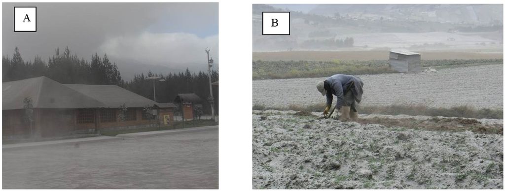
Weak ashfall occurred in central Machachi and in the El Chaupi, Pichincha, as well as in parts of the canton Rumiñahui.
Ash emissions continue with similar intensity
Update Thu 27 Aug 08:13
Cotopaxi volcano spewing ash this morning
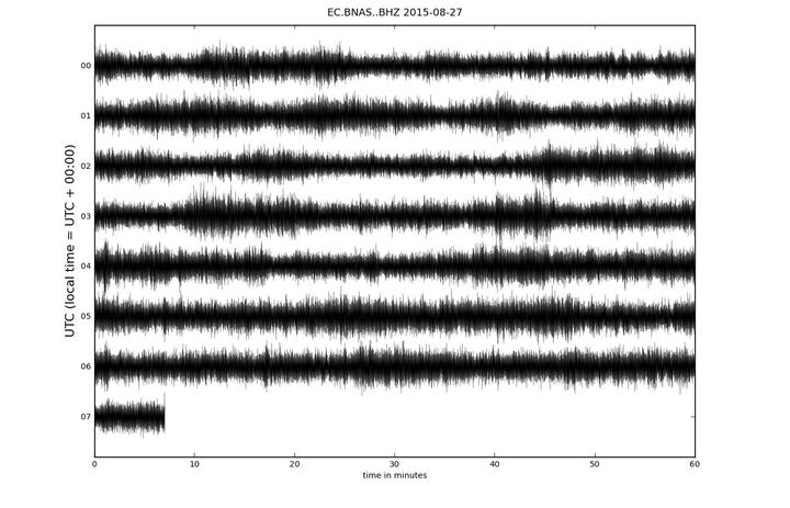
Current seismic trace (BNAS station)
No significant changes have occurred. The volcano continues to produce near-continuous ash plumes that rise 1-2 km above the summit and drift into westerly directions.
Volcanic tremor is continuous at the moment.
Continuous ash emissions, volcanic tremor
Update Tue 25 Aug 16:55
Ash emissions from Cotopaxi yesterday (photo: Patricia Mothes / IGEPN)
Ash emissions from Cotopaxi yesterday (photo: Patricia Mothes / IGEPN)
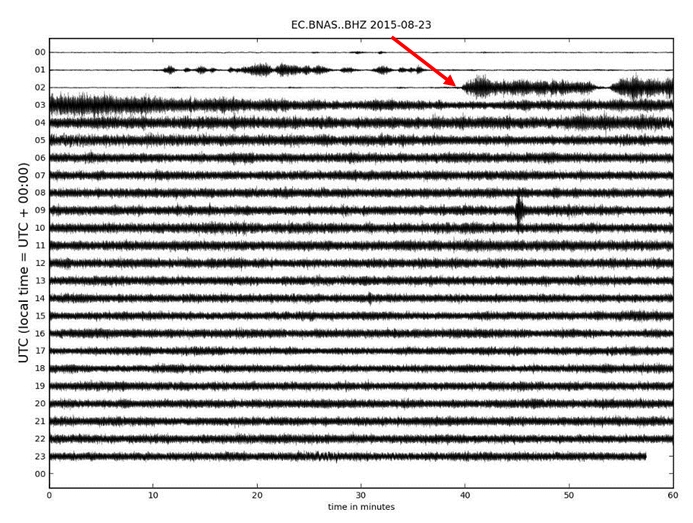
Onset of volcanic tremor during the evening of 22 Aug
The eruption continues with similar activity as during the past days, with a gradually increasing trend. Accompanied by near-continuous tremor, the volcano now produces almost constant, dense ash plumes rising up to 2 km and drifting into westerly directions, reaching the Pacific Ocean.
The current phase of near-continuous emissions started during the night 22-23 Aug, when volcanic tremor appeared suddenly at 21:41 local time. The next day, after 18 hours, 2 mm of new brown ash fall had accumulated on the western side in the Cotopaxi National Park.
During yesterday, a gradual increase in tremor and seismic energy were detected, corresponding probably to increasing internal pressure, and an increase in the volume of magma rising towards the surface. The height of the ash emissions also gradually increased to approx. 2 km.
Today, tremor has slightly decreased, but remains at similar levels as yesterday.
Continuing ash emissions 2 km high
Update Mon 24 Aug 09:07
Ash plume from Cotopaxi last evening
Activity at the volcano remains more or less similar with moderately strong, near continuous ash emissions producing a plume rising approx. 2 km and drifting into westerly directions.
This is the latest press release of the government:
"The Institute of Geophysics of the Polytechnic University reported that the volcanic activity has remained similar to that of the last past days. The evaporative emissions have contained a high presence of ashes which have reached up to 2000 meters over the crater and has been directed towards the West and Southwest side of the volcano.
Throughout the day volcano ash emissions continued to fall in the areas of Tanicuchi, Guaytacama, Chugchilán, Isinlivi, Mulaló, Lasso, Joseguango, Pastocalle and El Chasqui. Due to reports of ash fall over roads and highways the Ministry of Transport and Public Work has recommended the public to drive with caution and to not exceed a speed limit of 30 kilometers per hour.
Continuing with contingency plans, on Saturday night, the Secretary of Risk Management (SGR) coordinated an evacuation drill in the parish of Puerto Napo, district of Tena. While on Sunday, it trained 150 people from Barrio Centro, in the parish of Aláquez, district of Latacunga, and 129 people in the Libertad Bajo Joseguango parish. An evacuation drill was also conducted with 143 people in Quisinche Alto, the parish of Mulaló—Latacunga. Finally the authorities also gave out 1,280 clinical masks in Tanicuhí and 6,160 in Toacazo.
In the district of Rumiñahui, outside of the San Luis Shopping Center, the autonomous local governments of Quito and Rumiñahui organized a citizen fair—“Looking at the Volcano”—where various institutions within the field of prevention provided information on shelters and safe meeting points in risk areas.
As a protective measure from any ash fall we remind you to always carry with you a clinical masks, appropriate protective glasses, and a hat. In addition, we remind you can access volcano related and up-to-date information at www.volcancotopaxi.com"
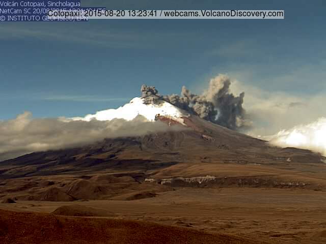
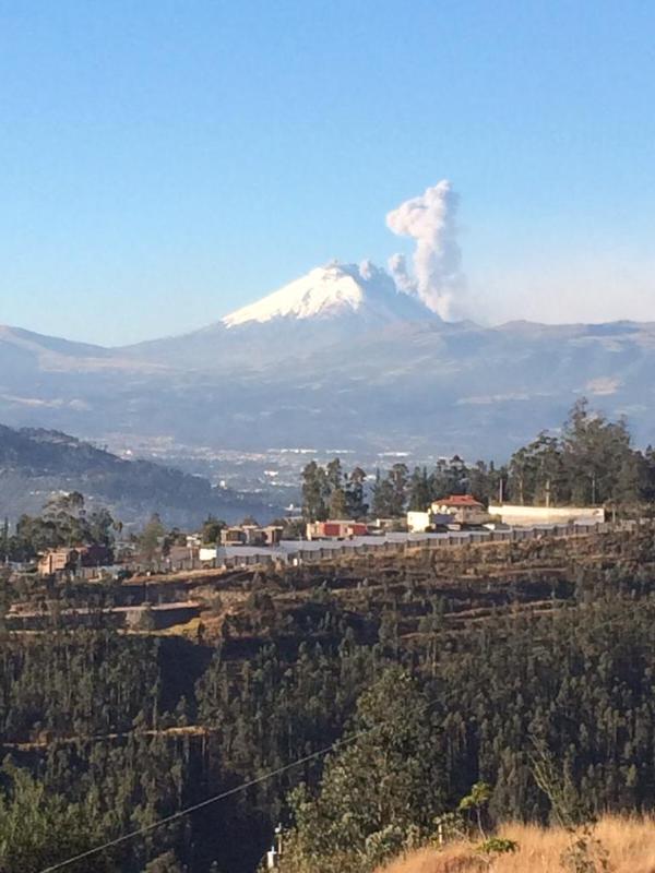
Increasing ash emissions
Update Sun 23 Aug 19:24
Ash plume from Cotopaxi seen from Quito yesterday (Image: Ministerio Coordinador de Seguridad)
Ash emissions have been increasing and producing plumes that rose 2 km above the summit and drifted west for over 50 km.
Ash fall occurred in several populated areas including Mulalo, Chaupi, Lasso, Machachi, Aloag, Tambillo.
According to Ministry of Security, evacuation routes and over 120 "albergues" - shelters - have been prepared to accommodate people in case evacuations become necessary.
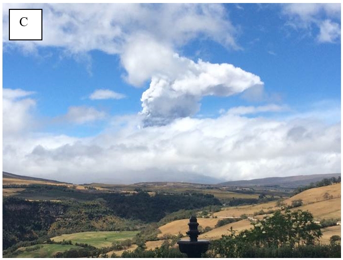
New ash emissions yesterday - satellite images
Update Fri 21 Aug 09:44
The volcano continues to be relatively calm. Modest ash emissions occurred yesterday producing plumes that rose a few 100 m above the summit and were then pushed down by strong winds along the flank of the volcano.
A beautiful 3D view of the volcano based on satellite images was published by Agroprecision / Airbus:
Activity remains low
Update Wed 19 Aug 13:47
volcano remains calm. Only low-energy degassing is being observed from the summit crater. During yesterday's overflight, no significant changes to the crater morphology have been detected.
The explosions from Friday and Saturday were likely phreatic in origin, i.e. did not involve fresh magma directly.
Aerial view of Cotopaxi's crater
Update Tue 18 Aug 18:21
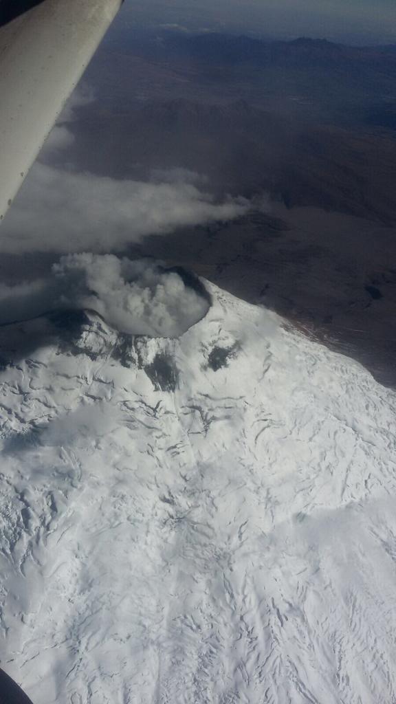
Aerial view of Cotopaxi today (image: IGEPN / Seguridad Ecuador / twitter)
Update Tue 18 Aug 13:53
Eruption from Cotopaxi this morning (image: juan jose espinosa p / twitter)
During the night and this morning, some relatively small explosions occurred at the volcano, producing plumes of up to 700 m height.
Volcano remains calm (so far)
Update Mon 17 Aug 12:22
No new explosions of significant size have occurred at the volcano during the past 48 hours. Seismic activity remains elevated and suggests that smaller ash emissions continue, however.
Whether this is only a pause before another, possibly more violent phase of the eruption or already an end of this episode is too early to say.
Ecuador's
ministry of civil protection maintains yellow alert for the communities of Francisco, Rumipamba, San Ramón, Mancheno, José Guango Bajo, and San Agustín del Callo (Mulaló).
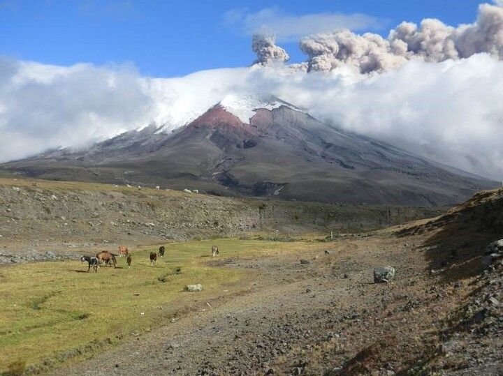
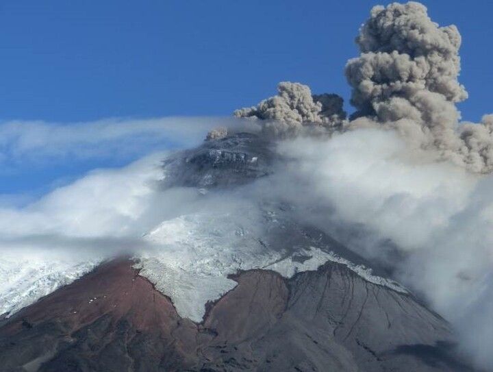
Cotopaxi volcano (Ecuador): new eruption with powerful explosions
dim., 16 août 2015, 11:11 11:11 AM | AUTEUR : T
Eruption from Cotopaxi on 14 Aug (photo: Daniel Salazar / twitter)
The volcano started to erupt, for the first time after more than 70 years, on 14 Aug with a series of 6 very strong explosions. The volcano last erupted in 1940 and possibly 1942. A major hazard of glacier-clad Cotopaxi's eruptions are melt-water floods that can turn in to devastating lahars and threaten an area with approx. 300,000 inhabitants.
The first explosion on 14 Aug occurred at 10:50 local time with an ash plume that rose approx. 8000 meters above the summit crater. During the same day, it was followed by 5 more explosions of similar or smaller size. Some of the explosions produced pyroclastic flows.
The volcano calmed down a bit during yesterday, but had another explosion in the afternoon.
The Ecuadorian government has declared a state of emergency for the area around the volcano and ordered evacuations. During 14 Aug, more than 400 people were evacuated from Loreto del Pedregal village on the northern foot of the volcano.
Precursors of the eruption:
The eruption had been preceded by a brief seismic crisis that started on 13 Aug and culminated in two smaller, probably phreatic explosions at 04:02 and 04:07 in the early morning the same day. Ash from the explosions, which were not observed, but heard, drifted NW and reached up to 40 km distance towards the capital Quito, where it was found as a dusting of fine ash.
During April-June, the volcano had experienced a prolonged period of seismic unrest, with more than 3000 earthquakes during May. This crisis had faded by the beginning of August, but now becomes clear to have been a precursor of the current eruption.
Whether the eruption involves new magma or is purely phreatic in origin remains unclear, but ash analysis will probably give an answer soon.
First visit to our site? If you havn't done it yet,
download the Volcanoes & Earthquakes app to get one of the fastest volcano news online:
Android |
IOS